The town of Bridgend was historically in the county of Glamorganshire, South Wales. It is situated on the River Ogmore, a short distance upstream from the Bristol Channel. Its Welsh name ‘Pen-y-Bont Ar Ogwr’ translates to ‘the head of the Bridge on the Ogmore’. The town serves as the administrative centre for the county borough of Bridgend. It’s also located about 20 miles (32 km) west of the Welsh capital, Cardiff, and a similar distance east of Swansea. At the 2011 UK Census, the town had a recorded population of 49,404. Bridgend grew rapidly into an agricultural town.
A Fleeting History
Early Days
There is archaeological evidence that suggests that habitation of the Bridgend area dates back to at least 1500 BC. Bronze Age burial mounds have been found on Stormy Down, Iron Age Forts at Dunraven and flint arrowheads on Merthyr Mawr Warren. Primitive Iron Age smelting hearths have also been found at Sunnyside, beneath which cremated Bronze Age remains were found.
There is also plenty of proof to suggest the Romans were active around Bridgend but there’s no trace of a military encampment. However, coins and other artefacts have been found in the area, especially along the A48. This was the route of the old Roman military road from Isca (Caerleon) to Nidum (Neath), which skirts the town to the south.
The Normans
Following Norman conquest of Anglo-Saxon England in 1066, William the Conqueror, looked westwards to Wales to expand his kingdom. A number of Norman Lords soon arrived in the south and east Wales to claim a manor. Conversely, the north and west of Wales remained largely unconquered due to the harsh, unforgiving terrain. Local Welsh chieftain Morgan Gam had already built a stronghold, close to Bridgend, at the nearby village of Coity.
Late in the 11th century, the Norman nobleman Payn de Turberville negotiated with Morgan to turn over control of Coity Castle to him on peaceful terms. However, Morgan Gam’s response was to offer Turberville a polarised choice, either fight for the land or take his daughter’s hand in marriage. Turberville took the latter option and married Gam’s daughter Sybil to become Lord of Coity.
Throughout the 12th century, the Normans continued to increase their stranglehold on the area. Newcastle Castle was built on Newcastle Hill in 1106. It overlooks today’s town centre built by Robert Fitzhamon. In 1116, Ogmore Castle was built by William de Londres. In 1141, just 2 miles north-east of Ogmore Castle, Maurice de Londres founded the fortified Benedictine Ewenny Priory. By the 1180s, Sir Gilbert de Turberville had inherited the Lordship of Coity Castle. It was during his tenure, the castle was refortified with stone.
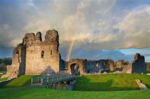
Ogmore Castle. Image credit: Billy Stock/Shutterstock.com
The medieval settlement of Bridgend began to develop at a ford crossing of the River ‘Ogmore’, between the villages of Newcastle and Oldcastle, which lay on the main route between east and west Wales. The river took its name from the Welsh for salmon, ‘Eog’ and the old Welsh word ‘Môr’, which referred to ‘an expanse of water’. Early Norman documents, refer to the river as ‘Oggemor’, ‘Uggemore’, or ‘Ogmor’.
Late Middle Ages
Starting in 1401, the rebellion by Owen Glendower, the self-proclaimed Prince of Wales, against the rule of Henry VI, caused much damage to anything with Norman identity, including castles, churches and farms. Coity Castle, by then under the jurisdiction of Sir Lawrence Berkrolles, was besieged by Glendower’s forces. The siege was later relieved later by the King’s forces, but Coity was one of the few castles to hold out against Glendower.
Around 1425, a stone bridge was built at the site of the ford over the River Ogmore, which gave rise to the town’s name. It was partially demolished by a great flood in 1775 when two of its four arches were washed away, later being replaced by a large single span. The name Bridgend (‘Penybont ar Ogwr’ in Welsh), in Old English, ‘Bryggen Eynde’, was first documented in about 1447. By this time the town was developing in tandem in two parishes; Newcastle and Coity, which were divided by the River Ogmore.
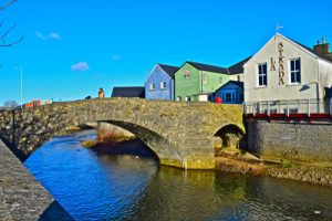
The ‘Old Bridge’ was built circa 1425 (restored 2005). Image credit: Colin Burdett/Shutterstock.com
By the beginning of the 16th century, Bridgend, given both its favourable geographical and topographical location, had developed as the areas main market town. The next real development of the town was not until the dawn of the Industrial Revolution. During the latter part of the 18th century, a number of tanneries, a woollen factory and a few potteries sprung on the outskirts of the town. In the town itself, the support services for agriculture were growing, with an iron foundry making implements and farm machinery, being established.
The 19th Century to WW2
The iron and coal mining industries developed in earnest at the beginning of the 19th century in the area. However, with Bridgend being outside the southern limit of the coalfield, it essentially retained its agricultural and market character. Instead, it became the shopping and business centre for the coal mining valleys. In the 1820s and 1830s, new roads to Cowbridge and Aberkenfig, and a new road bridge, opened the town to more through traffic and the corresponding trade that followed.
In 1839, the Bridgend Railway opened, which was a horse-drawn tramway, branching from the Dyffryn Llynfi and Porthcawl Railway. It survived for 30 years, bringing coal from the upper end of the Llynfi Valley. South Wales Railway (SWR) opened its Bridgend station in 1850. The Vale of Glamorgan line of the Barry Railway was opened in 1897.
By the late 19th-century limestone quarrying had also developed as an important industry in the area. A number of buildings in Bridgend were built of the local stone during the era, the last notable one being St. Mary’s Church in Nolton, which was completed in 1887, and its tall spire in 1898. As the new century arrived, Bridgend was very much a market town and residential area, with the local economy being very much dependent on agriculture and the business brought by coal mining in the northern valleys.
The town’s character did not really change until the building of the vast Royal Ordnance Factory at Waterton immediately before the outbreak of World War II. At its peak, the arsenal had 40,000 workers, many of them women, who were transported by bus from the Rhondda and surrounding valleys. However, during WW2, although a few air raids did occur just outside the town, Bridgend itself was lucky enough to largely escape any bombing from the Luftwaffe.
In 1948, Newbridge Fields, a short distance from the town centre, hosted the 1948 National Eisteddfod, the leading annually held Welsh festival of music and culture.
The Modern Era
In 1960, Bridge was subject to severe flooding from the River Ogmore. Subsequent floods and extreme weather led the Welsh Water Authority to develop concrete flood defence walls along the banks of the River Ogmore. The 1960s saw the loss of vital rail links to the Vale of Glamorgan and the northern valleys under the ‘Beecham’ countrywide review and subsequent ‘cuts’ to the railways. However, transport connectivity to the town was greatly enhanced in the 1970s, when the M4 section of the motorway that now skirts Bridgend, was finally completed.
In the 1970s, two major multinational corporations, i.e. Ford Motor Company and Sony, set up factories on the new Bridgend Industrial Estate. Beginning in the 1980s, the continuing development of the Brackla and Broadland housing estates has supported a steady rise in the town’s population. In 1997, a new link road and bypass was completed, linking the town centre directly with the M4 motorway. Also in 1997, HM Parc Prison near Coity was opened.
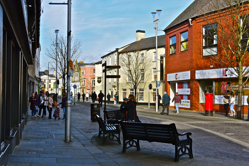
In 2004, a new bus station opened, the town centre was pedestrianised and considerable improvements were made to the town’s traffic management system were made.
While companies set up in Bridgend, include Ortho-Clinical Diagnostics, Staedtler, engineering consultancy Skanska, aeronautic maintenance and project management company TES Aviation, home accessories manufacturer Dekor and Semiconductor Photomask Company, bad news for jobs in the town was announced in July 2019. Ford has stated that 1,700 workers at the Bridgend engine plant will lose their jobs in the autumn of 2020. Ford blamed “changing customer demand and cost” for the up-and-coming factory closure.
Getting There!
By Air
Cardiff Airport is about 15 miles (25 km) to the southeast of Bridgend. The link is served by an hourly train service from nearby Rhoose, as well as a shuttle bus, which runs directly from the airport terminal. The bigger international Bristol Airport is located some 63 miles east of Bridgend.
By Train
Bridgend is a scheduled stop on the GWR hourly service between London Paddington and Swansea. All other services are run by TFW Rail. Their services connect Bridgend to Cardiff, Barry, Swansea, Carmarthenshire, Pembrokeshire, Manchester, Birmingham and Western England. Bridgend’s second station is Windmill, which is on the Valleys rail network. It serves the districts in the north of the town and operates an hourly service between Maesteg and Cardiff/Cheltenham.
By Car
Bridgend is most easily reached via Junctions 35 and 36 of the M4 motorway, which runs between London to Carmarthenshire.
By Bus
National Express operates long-distance services between Bridgend and major destinations throughout the rest of the country. The drop-off/pick-up point for the service is at the McArthur Glen Designer Outlet, which is about 2 miles from the town centre. There are plenty of local bus services which connect between the two points.
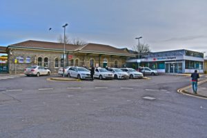
Bridgend Railway Station is the 5th busiest in Wales. Image credit: Colin Burdett/Shutterstock.com
Did you know?
• Bridgend’s Island Farm POW Camp saw the biggest escape by German prisoners, that were held in Britain, during WW2. In 1945, eighty-six prisoners managed to escape through a 70 ft (21 m) long tunnel. However, all of the escapees were recaptured within a matter of days.
• Merthyr Mawr sand dunes, just 3 miles from the centre of Bridgend, was a shooting location for some of the scenes in the 1962 blockbuster film ‘Lawrence of Arabia’.
Famous People
Famous people born in or around Bridgend, include:
- Huw Edwards – current and prominent journalist and newsreader
- Carwyn Jones- current politician, who served as First Minister of Wales, between 2009 and 2018
- Ruth Jones (MBE) – actress and writer, probably best known for the comedy ‘Gavin and Stacey’
- (Dennis) Howard Marks – notorious drug smuggler and criminal, who later achieved fame as an author
- John Peter Rhys Williams – Welsh rugby union international and iconic sporting figure of the 1970s, who was better known simply as ‘JPR’
- William Morgan – inventor of the X-ray process
Sport in Bridgend
Bridgend Ravens
Rugby Union is the national sport of Wales. Bridgend Ravens (formally Bridgend RFC) were founded in 1878. They are a semi-professional rugby union that plays in the Welsh Premier Division. They are the leading rugby team in Bridgend and play their home matches at the Brewery Field. The club has been Welsh champions five times and has twice won the WRU Challenge Cup. The club has on occasions beaten international touring teams at the Brewery Field, which famously includes Australia in 1981.
Pen-y-Bont F.C.
The local football team, Pen-y-Bont, plays in the Welsh Premier League, the top level of Welsh football.
Things to see and do!
- Coity Castle – is a Grade I listed ruin of an early 12th century Norman castle near the village of Coity. There are no on-site facilities but on the upside – it’s free entry!
- Ogmore Castle – is a Grade I listed ruin of an early 12th century Norman castle near the village of Ogmore-by-Sea. It’s located just south of the town of Bridgend, situated on the south bank of the River Ewenny. There are no on-site facilities, apart from a small car park, but on the plus side – it’s free entry!
- Bryngarw Country Park – is a 48 hectares (120 acres) of Grade II listed historic park and garden with a period country house. Amenities include a visitor centre, café, adventure playground, and barbeque/picnic areas. It’s located about 5 miles north of Bridgend.
- Skyr Beach (aka Kenfig Sands) – is an isolated, quiet, clean, sandy beach, inaccessible to vehicles. It’s about a 20-minute walk from the nearest road. Great place to walk the dog, explore with the kids, or just chill out! It’s about 8 miles west of Bridgend.
- Parc Slip Nature Reserve – is a 98 hectares (247 acres) of wetlands and countryside with a variety of different habitat types supporting many species of wildlife. For cyclists, there are well-maintained traffic-free cycle tracks. There’s also a large car park and a visitor centre, with the obligatory coffee shop.
Where to stay?
There’s a decent range of accommodation in and around Bridgend, especially given the size of the town. Holiday-style accommodation is limited and tends to be further afield than the immediate town. A broad indication of prices for the available types of accommodation in and around the Bridgend area is:
- B & B/Guesthouses/Standard Hotels: £40 – £70
- 3/4/5 Star Hotels: £70 – £150
- Holiday Home/Apartments: £200 – £300 (between 2 & 6 adults sharing)
Moving to Bridgend?
Thinking of moving to Bridgend? The overall average property price in the Bridgend area for the year leading up to April 2022 stood at approximately £208,000. This is up around 7% on the average price paid in the previous year. In terms of property types, semi-detached houses were the best-sellers at an average of £192,000. Flats sold for an average of £110,500, terraced hoses for £151,000, and detached houses for £287,000.
Thinking of a Staycation?
Are you thinking of holidaying in the UK? If so, why not check out some of our other travel guides for some staycation ideas. I think you might be surprised at the variety of great things to do in the UK.