The London Borough of Bexley is situated in outer south-east London. The London Borough of Bexley was formed in 1965 under the London Government Act of 1963. It came from the merger of the Municipal Boroughs of Bexley and Erith, the Urban District of Crayford and part of the Urban District Chislehurst and Sidcup. It borders the London Borough of Bromley to the south, the Royal Borough of Greenwich to the west and the River Thames to the north.
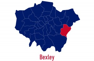
Image: mapsandphotos/Shutterstock.com
It also borders with the Borough of Dartford to the east and Sevenoaks district to the south-east. The Borough of Bexley lies within the area designated as the Thames Gateway, a controversial national urban regeneration scheme. The population of the Borough of Bexley at the 2011 UK Census was 231,997.
A Very Brief History
The village of Bexley originated sometime during the 5th century, and it’s documented that it received its first charter as early as AD 814. In the Domesday Book of 1086, Bexley is referred to as the village of Bix, which is recorded as having 3 mills, 41 residents, and 10 smallholders.
By the 17th century, the small port of Erith had been established on the River Thames. However, the area we now know as the Borough of Bexley remained practically unoccupied until the 19th century. In 1849, the railway came to Erith and then sewage works opened at nearby Crossness towards the end of the century, which contributed to the rapid growth of the town. The population of the Borough had grown from just over 4,000 in 1801 to almost 45,000 by 1901.
In 1894, Bexley became an Urban District Council, with its administrative centre being established at Bexley Heath. During WWI, the village of Crayford quickly developed into a small town due to the presence and growth of local munitions works. By 1920, the Parish of Crayford had been established as an Urban District. Throughout the 1920s and ’30s, Bexley and Foots Cray, which was re-named Sidcup in 1921, experience rapid urbanisation during the great housing boom of the era. In 1934, Sidcup merged with Chislehurst and North Cray to form Chislehurst and Sidcup Urban District Council. And in 1935, in recognition of its rapidly increasing population, Bexley became a Municipal Borough. By this time, the overall population of today’s Borough was around 110,000.
Today, the Borough of Bexley is best known for its many historic sites and beauty spots such as the ruins of Lesnes Abbey in Abbey Wood, Hall Place and Redhouse, William Morris’s home in Bexleyheath. Danson Park in Welling with its Palladian villa and boating lake is the largest public open space in outer London.
The Borough is twinned with Évry, France; Arnsberg, Germany and Footscray, Victoria, Australia.
Notable People
Famous or prominent people who were born, have lived or are living in the Borough of Bexley, include:
- Sir John Champneys (1495–1556) – Lord Mayor of London in 1534. He is buried in St. Mary the Virgin Church in Old Bexley
- Sit Hiram Maxim (1840–1916) – Inventor of the Maxim Gun moved his works to Crayford in 1884 and lived in Stoneyhurst from then until 1889
- William Morris (1834–96) – Artist, designer, and renowned socialist, lived for much of his life in Red House at Bexleyheath
- Michael Crawford (1942–) – Famed actor and singer of stage and screen, grew up in Bexleyheath
- John Paul Jones (1946–) – Bass guitarist of the mega rock group Led Zepplin, born in Sidcup
- Roger Moore (1927–2017) – Actor, lived in Wansunt Road, Bexley, during his marriage to Dorothy Squires
- Bernie Ecclestone (1930–) – Formula 1 magnate, lived in Bexleyheath as a child

Bernie Ecclestone lived in Bexley Heath as a child Image: Pat Lauzon/Shutterstock.com
Getting Around Bexley
Generally, it’s quicker and cheaper to take public transport rather than drive around London, as you may be liable for additional charges such as bridge tolls, congestion tax, etc. For bus travel, you will need a valid travel card such as the Oyster Card. Bus travel can work out cheaper than other forms of transport if you intend to do a lot of travelling around.
Road
There are five principal roads that pass through the Borough, which are: the A2 Trunk Road to Dover; the A20 (Sidcup By-pass); the A207, which lies on the line of the old Roman Road, Watling Street, providing an alternative route to Dover; the A206 which takes traffic from Woolwich and Dartford; and the A2016 through Thamesmead.
Rail
There are three suburban railway lines crossing the Borough which converge at Dartford. Bexley has no Underground lines or any other London-based mass transport system like Tramlink, the Docklands Light Railway or London Overground. Future Crossrail services will serve Abbey Wood station.
Railway Stations
- Abbey Wood
- Albany Park
- Barnehurst
- Belvedere
- Bexley
- Bexleyheath
- Crayford
- Erith
- Falconwood
- Sidcup
- Slade Green
- Welling
On Foot
There are also some long-distance footpaths in the Borough, which include the Thames Path and the London Outer Orbital Path. Bexley Borough also has joined with three other neighbouring boroughs in forming the Green Chain which links green spaces.

The Thames Path runs through the Borough of Bexley
Things to see and do!
Famed for its parks, open spaces and historic sites, the best-known attractions in or close to the Borough of Bexley are listed below.
- Red House – Former home and gardens of William Morris, founder of the arts and crafts architectural movement.
- Danson House – Grand 18th-century mansion with a surrounding park.
- Hall Place – A 1537 stately home with extensive landscaped gardens, built for Sir John Champneys, a wealthy merchant and former Lord Mayor of London.
- Crossness Pumping Station – Former sewage pumping station designed by Sir Joseph Bazalgette and architect Charles Henry Driver
- Lesnes Abbey – ruined building in Abbey Wood.
- Foots Cray Meadows – 97 hectares of parkland and woodland 97 hectares.
- Severndroog Castle – Folly situated in Oxleas Wood, Shooter’s Hill designed by architect Richard Jupp.
- High Elms Country Park – Spacious park with trails & a golf course.
- Oxleas Wood – Ancient deciduous forest in Eltham.
- Scadbury Park – 300-acre reserve with wildlife trails.
- Lesnes Abbey Woods – located near to, and named after, the ruined Lesnes Abbey.
- Lamorbey Park – 57 hectare park, set around a Grade II listed mansion, Lamorbey House.
- Crossness Nature Reserve – Open marshland with many bird species.
- Beacon Wood Country Park – Wooded park with trails & scenic views.
- Shoulder of Mutton Green – A public open space in Welling.
- Swanscombe Heritage Park
- Eltham Park North
- Eaglesfield Park
- Shrewsbury Park
- Winn’s Commo
- Eltham Park South
- The Slade Ravine
- Hoblingwell Wood Recreation Ground
- Oxleas Meadows
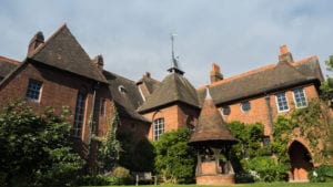
Red House in Bexleyheath – former home of William Morris
Where to stay?
You’ll be hard pushed to find any hostel-style accommodation in Bexley itself. However, there’s plenty of B & B/Guesthouse/Basic Hotels style accommodation on offer. If you’re looking for a bit more luxury then there’s also plenty 3, 4 and 5-star hotels in the area. Accommodation costs are generally quite favourable when compared to most of the rest of London. An alternative to a hotel would be to rent an apartment – most have no minimum let period. While the majority of apartments cater to couples, some can accommodate up to 6 people. Indicative prices for the most readily available types of accommodation/per night, based on 2 adults sharing are as follows:
B & B/Guesthouse/Basic Hotel: £60 – £125
3/4/5 Star Hotel: £125 – £250
Apartments vary greatly based on no. of available berths, location and standard
If you want to check out more London guides, feel free to click the link below.