A quick guide to Alston (Cumbria)
Alston is a relatively remote, small market town located in Cumbria, Northwest England and its main claim to fame is that it is the joint highest Market Town in England at around 1000 feet above sea level! It is situated within the civil parish of Alston Moor, lying close to the conjuncture of the River Nent and the River South Tyne. The town is located 45 miles (72 km) west of Newcastle, 30 miles (48 km) southeast of Carlisle, and 20 miles (32 km) northeast of Penrith. Historically part of Cumberland, Alston lies within the ‘North Pennines’ Area of Outstanding Natural Beauty (AONB). Much of the town centre also has the status of ‘Conservation Area’.
Go to the Cumbria Business Directory
A Fleeting History
Early Times
Archaeological artefacts which have been unearthed 2 miles from Alston at Kirkhaugh indicate that the area was first settled as early as 2000 BC. The Romans were the next in the area. As early as the 2nd century, they built the large fort of Epiacum (Whitley Castle) about 3 miles from Alston. The main purpose of the fort was to guard the supply lines to Hadrian’s Wall and protect the area’s lead and silver deposits.
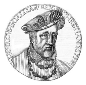
Henry II granted the ‘Liberty of Tynedale’ to Scotland in 1237
Up until the 11th century, Alston along with the rest of the Kingdom of Northumbria fell under the rule of the Anglo-Saxons. However, in 1076, Waltheof of Northumbria, the last of the Saxon earls was beheaded at Winchester, being the last resistor to the Norman rule of England. Thus Alston, as part of Tynedale, now fell under the rule of William the Conquerer. However, Tynedale did not become an ordinary Norman barony. Instead, it became a class of lordship termed a ‘Liberty’, where the baron was responsible for performing the administrative and judicial tasks, undertaken elsewhere by a sheriff and other royal officials. Around the mid-12th century, Alston got its first church.
The Liberty of Tynedale
In 1237, the Treaty of York saw Alexander II of Scotland abandon his claim to the counties of Cumberland and Northumberland. As a reward, Henry II granted him the ‘Liberty of Tynedale’, along with some land and forest at Inglewood in Cumberland. In 1297, the Northumberland Assize Roll described Tynedale as being ‘outside the kingdom of England in the kingdom of Scotland’. However, despite the land being under the jurisdiction of Scotland, legally the Tynedale liberty remained part of England.
In 1296, on the very day that the Scots were crushingly defeated at Dunbar, Edward I gave instructions that “no adherents of John de Balliol late King of Scotland be allowed to remain on their English lands”. Thus, Tynedale, including Alston, was transferred to the rule of the English Monarchy. However, the ‘Liberty’ remained in place for a further 200 years, meaning that the Tynedale area was subject to different laws and legislation than the rest of England.
In 1495, the liberty status of Tynedale was removed, meaning Alston was now subject to the laws of state once more. By this time, mining, as well as farming, had become important to the local economy, with lead, silver, zinc, coal and fluorspar all being exploited.
The 18th Century
From the 17th century onwards, the town of Alston began to grow up arbitrarily around the parish church. By this time the area was particularly famed for its lead mines. By the late 17th century the population of the town had grown to around 600 and a weekly market had been established. Small-scale quarrying of sandstone and limestone had also begun to develop, alongside mining. However, mining remained on a very modest scale until the arrival of the Industrial Revolution in the mid-18th century. By this time, Alston had a school, a library, a surgeon, and a market hall with a clock tower.
In 1750, the London Lead Company obtained long-term mining rights to the Alston area. By the early 19th century, the company established a model village at Nenthead for its workers. In 1802, a new cotton mill had built in the town on the River Nent which further boosted the town’s employment opportunities. In 1831, with a booming local economy, the population of the parish peaked at 6,858. By this time, Alston had pretty much developed as a collection of tightly clustered rows of houses with narrow cobbled lanes.
The Victorian Era
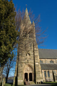
Today’s St Augustine’s Parish Church was built in 1869. (Credit to H. Athey)
In March 1852, the Newcastle and Carlisle Railway Company opened a branch line between Haltwhistle and Alston to aid the exploitation of the mineral wealth of Alston Moor. However, it was only several months later that the line was also open to passengers. In 1869, the existing St Augustine’s Parish Church was built. It replaced an earlier church on the same site, built in 1769, that had been designed by celebrated Civil Engineer John Smeaton. In 1776, Smeaton also worked on a grandiose project at Nenthead Lead Mine, the ‘Nent Force Level’. The project wasn’t completed until 1842, at a final cost of more than £80,000. The 8 km underground canal did work on draining the mine, but it didn’t open up the expected strikes of new ore and was in time, dubbed “Smeaton’s Folly”.
During the 1870s, the world price of lead suffered a significant and prolonged period of decline. In 1882, the London Lead Company withdrew from the Alston area. This now led to a long period of stagnation and decline for Alston. Around 1870, a carpet-making factory started up at the old cotton mill, but by 1890 it had closed. By 1901, with employment becoming increasingly difficult to find in the town, the parish population had fallen to 3,134. It continued to decline across the 20th century.
A Resurgence
During World War II, the town experienced some resurgence when a steel foundry was established on the site of the old cotton mill to manufacture munitions. In 1947, a Precision Casting company was established in the town by William George Ball. Although some mining managed to continue into the 20th century i.e. zinc, barytes and fluorspar, all mining had almost ceased by 1950. However, the small drift coal mine of Ayle Colliery, opened in 1926 by Stanley Shepherd, has managed to buck the trend and is currently still trading (2020) in a limited capacity.
The Modern Era
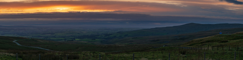
Alston is one of the highest towns in England. Photo credit: H. Athey
In 1962, Alston’s rail link with Haltwhistle was recommended for closure under the Beeching Report. However, the closure was rejected due to the lack of an all-year-round reliable road link. After the road was upgraded in 1973 closure was again proposed. The service on the line had been sketchy at best for a number of years but was officially closed on 1 May 1976.
In 1989, Alston’s Steel foundry, set up during WW2, closed with the loss of around 200 jobs, increasing local unemployment from 9% to 25%. In 2019, the area’s main employer was Bonds Precision Castings Limited, a company that took over the Precision Castings Company in 2008. However, at the end of 2019, the company went into receivership without finding a buyer, meaning Alston lost a further 55 jobs.
Today, tourism is now an important source of income for the area. And, while farming is still important to the area, particularly sheep farming, many farmers also run other enterprises, such as bed and breakfast accommodation. There’s also a regular producers’ market which takes place at the town hall from April to September. It sells locally produced food, such as cheese and mustard, as well as a variety of food and crafts from around the region.
While there are now only four public houses in the town, there are a good number of family-run cafes and bespoke shops. In the 2011 UK Census, the population of Alston was recorded as being 1,105 while that of the whole Parish of Alston Moor was 2,088.
Getting there!
By Road
By far the easiest way to get to Alston is by private car. From the West, the easiest way to get to the town is to take the M6 to Penrith and then take the A686 directly to Alston. Alternatively, from Carlisle take the A69 to Haltwhistle, and then the A689 to Alston. From the East, take the A69 from Newcastle to Hayden Bridge then the A686.
By Bus
Go North East operates two buses a day between Haltwhistle and Alston. Connection to Haltwhistle can be made by either bus or train from both Carlisle and Newcastle. Wright Brothers also operate a limited bus service between Newcastle and Keswick, which travels via Hexham, Haydon Bridge, Alston, and Penrith. However, the service only operates during the summer months i.e. July to September. There is also a term-time bus service that operates between Carlisle and Alston, primarily for college students.
By Train
Haltwhistle is marginally nearer to Alston than Penrith, but Penrith’s West Coast mainline station is much easier to get to. It’s around 21 miles from Penrith station to Alston. Bus services are limited so far by the easiest way to get there is to hire a car.
By Air
Carlisle is the nearest airport to Alston but only offers flights to/from Dublin, Belfast, and Southend (London). Newcastle International Airport is only a little further away at 42 miles but offers far more destinations
A Notable Son
Nicholas Ridley was born in the South Tynedale area, around 1500. He became the only clergyman ever to achieve the title of the ‘Bishop of London and Westminster’. Sadly, he came to an unfortunate end, being one of the Oxford Martyrs at the time of the English Reformation. On 16 October 1555, he was burned at the stake for his teachings and faith, and not least of all, his support for Lady Jane Grey. He is remembered with a commemoration in the calendar of saints in some sectors of the Anglican Church.
Did you know?
- Alston has on occasion been used as the backdrop for the shooting of a number of TV period dramas.
- Alston’s Samuel King’s School has the smallest secondary school attendance in England. In 2020, that was just 83 pupils.
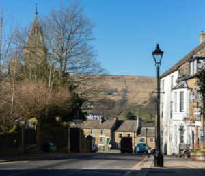
- Set at an altitude of around 1000 ft, Alston (along with Buxton in Derbyshire) has claims on the title of being the ‘highest market town in England’.
- Alston, according to the writers, was the inspiration behind the fictional town of Royston Vasey featured in the BBC television comedy series ‘The League of Gentlemen’.
- Alston is one of the coldest inhabited places in England. During the coldest month of February, the average maximum temperature is only 4 deg C.
Walkers and Cyclists
Alston is recognised as a ‘bit of a mecca’ for walkers and cyclists
With its unique geographical location, Alston is a bit of a ‘Mecca’ for those who enjoy long-distance walking and cycling. Some of the main attractions are:
- The Pennine Way – Alston Youth Hostel is situated directly on the Pennine Way and 174 miles into the 268-mile route if travelling northwards.
- The Coast to Coast (C2C) Cycle Route (National Route 7, 14 & 71) – Alston is about halfway on the 135-mile C2C route. Alston’s hostel makes an ideal place to stay over.
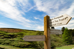
- Isaac’s Tea Trail – is a long-distance footpath within the North Pennines AONB. The 37-mile circuit links Allendale, Nenthead, Alston, and Ninebanks, crossing high moorland and the East Allen, Nent, South Tyne and West Allen valleys. The route was inspired by the antics of local Victorian grocer, Isaac Holden. He walked the route delivering tea to remote farms and hamlets.
- South Tyne Trail – follows the 23 miles long course of the River South Tyne from its source in the North Pennine Fells to Haltwhistle. Alston hostel is 9 miles into the route if travelling northwards.
- Hadrian’s High Way – is a 102-mile trail starting at Ravenglass on the West Cumbrian coast and finishing at Vindolando fort on Hadrian’s Wall passing through Alston.
Things to See and Do
- Nenthead Mines Heritage Centre – is an award-winning former lead mine, located about 6 miles from Alston. You can take an underground tour of the Carrs Mine and there are displays of minerals, mining equipment and historic photographs. There’s also a 100-metre deep shaft. While you can just turn up on the day, booking ahead is recommended to secure a place on a guided tour.
- South Tynedale Railway – is the North of England’s highest narrow-gauge railway. It runs from Alston for 5 miles through some spectacular scenery to the tiny hamlet of Slaggyford in Northumberland. Trains operate between April and October.
- Epiacum Roman Fort – (aka Whitley Castle) is just 3 miles from Alston. It’s been described by some as ‘the best preserved Roman Fort in the Empire’.
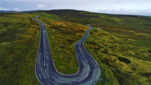
The ‘long and winding road’ – Hartside Pass is 6 miles southwest of Alston
- Alston Golf Course – just 2 miles from Alston is the highest golf course in England. Set well above the town centre, there are great views over Alston Moor. Visitors are welcome to play!
- Yad Moss Ski Slope – is located about 6 miles from the town centre on Alston Moor. The ski slope is only active as and when snow permits and definitely not recommended for beginners.
There are some ski tows on the northwest slopes of Burnhope Seat, a hill situated 4 miles (6.4 km) away from Alston. This forms the Yad Moss ski facility which has been upgraded by Sport England - Hartside Pass – is on the A686 between Penrith and Alston, about 6 miles from the town. It was chosen by the AA Magazine as one of their ‘Ten Great Drives’. The road climbs at the Pass to a height of 1904 ft (580 m) from where there are great views across the Solway Firth to Scotland. It also forms part of the ‘C2C’ Cycle Route. The famed ‘Hartside Cafe’ at the very top of the pass, was gutted by fire in 2108. However, it’s now under new ownership, with a planned reopening for 2020.
Where to stay?
Alston Youth Hostel offers the cheapest accommodation in town with the expected shared facilities. Prices very much depend on the time of year and the number of bookings. Accommodation in and around Alston is very much rural B & B/Guesthouse style. Expect to pay around £60 – £90 for 2 adults sharing per night.
Photo credit to H. Athey/Shutterstock.com as indicated.
